
![]()
Arizona is located in the Western United States as one of the Four Corners states. Arizona is the sixth largest state in area, after New Mexico and before Nevada. Of the state's 118,000 square miles, approximately 15% is privately owned. The remaining area is government forest and park land, recreation areas and Native American reservations.
 Arizona is best known for its desert landscape, which is rich in xerophyte
plants such as cactus. It is also known for its climate, which presents
exceptionally hot summers and mild winters. Less well known is the pine-covered
high country of the Colorado Plateau in the north-central portion of
the state, which contrasts with the desertic Basin and Range region
in the southern portions of the state.
Arizona is best known for its desert landscape, which is rich in xerophyte
plants such as cactus. It is also known for its climate, which presents
exceptionally hot summers and mild winters. Less well known is the pine-covered
high country of the Colorado Plateau in the north-central portion of
the state, which contrasts with the desertic Basin and Range region
in the southern portions of the state.
Like other states of the Southwest, Arizona has an abundance of topographical characteristics in addition to its desert climate. More than half of the state features mountains and plateaus and contains the largest stand of Ponderosa pine in the United States. The Mogollon Rim, a 2000-foot (600 m) escarpment, cuts across the central section of the state and marks the southwestern edge of the Colorado Plateau, where the state experienced its worst forest fire ever in 2002. Arizona belongs firmly within the Basin and Range region of North America. The region was shaped by prehistoric volcanism, followed by a cooling-off and related subsidence. The entire region is slowly sinking.
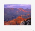
The Grand Canyon is a colorful, steep-sided gorge, carved by the Colorado River, in northern Arizona. The canyon is one of the seven natural wonders of the world and is largely contained in the Grand Canyon National Park - one of the first national parks in the United States. President Theodore Roosevelt was a major proponent of designating the Grand Canyon area, visiting on numerous occasions to hunt mountain lion and enjoy the scenery. (Source Wikipedia)
California borders the Pacific Ocean, Oregon, Nevada, Arizona, and the Mexican state of Baja California. With an area of 160,000 mi² (411,000 km²) it is the third largest state in the United States and is a little larger than Germany in size.
 California's geography is rich, complex, and varied. In the middle
of the state lies the California Central Valley, bounded by
the coastal mountain ranges in the west, the Sierra Nevada
to the east, the Cascade Range in the north and the Tehachapi
Mountains in the south. The Central Valley is California's
agricultural heartland and grows approximately one-third of
the nation's food. Divided in two by the Sacramento-San Joaquin River
Delta, the northern portion, the Sacramento Valley serves as the watershed
of the Sacramento River, while the southern portion, the San Joaquin
Valley is the watershed for the San Joaquin River; both areas derive
its name from the rivers that transit them. With dredging, the Sacramento
and the San Joaquin Rivers have remained sufficiently deep that several
inland cities are seaports. The Sacramento-San Joaquin Bay
Delta serves as a critical water supply hub for the state. Water is
routed through an extensive network of canals and pumps out of the delta,
that traverse nearly the length of the state, including the Central
Valley Project, and the State Water Project. Water from the Sacramento-San
Joaquin Bay Delta provides drinking water for nearly 23 million
people, almost two-thirds of the state's population, and provides water
to farmers on the west side of the San Joaquin Valley. The Channel Islands
are located off the southern coast. (Source Wikipedia)
California's geography is rich, complex, and varied. In the middle
of the state lies the California Central Valley, bounded by
the coastal mountain ranges in the west, the Sierra Nevada
to the east, the Cascade Range in the north and the Tehachapi
Mountains in the south. The Central Valley is California's
agricultural heartland and grows approximately one-third of
the nation's food. Divided in two by the Sacramento-San Joaquin River
Delta, the northern portion, the Sacramento Valley serves as the watershed
of the Sacramento River, while the southern portion, the San Joaquin
Valley is the watershed for the San Joaquin River; both areas derive
its name from the rivers that transit them. With dredging, the Sacramento
and the San Joaquin Rivers have remained sufficiently deep that several
inland cities are seaports. The Sacramento-San Joaquin Bay
Delta serves as a critical water supply hub for the state. Water is
routed through an extensive network of canals and pumps out of the delta,
that traverse nearly the length of the state, including the Central
Valley Project, and the State Water Project. Water from the Sacramento-San
Joaquin Bay Delta provides drinking water for nearly 23 million
people, almost two-thirds of the state's population, and provides water
to farmers on the west side of the San Joaquin Valley. The Channel Islands
are located off the southern coast. (Source Wikipedia)
The State of Colorado is defined as the geospherical rectangle that stretches from 37°N to 41°N latitude and from 102°03'W to 109°03'W longitude (25°W to 32°W from the Washington Meridian). Colorado is one of only three U.S. states (with Wyoming and Utah) that have only lines of latitude and longitude for boundaries.
 The summit of Mount Elbert at 4401 meters (14,440 feet) elevation in Lake
County is the state's highest point and the highest point in the entire
Rocky Mountains. Colorado has approximately 550 mountain peaks that exceed
4000 meters (13,123 feet) elevation. Colorado is the only U.S. state that
lies entirely above 1000 meters (3281 feet) elevation. The state's lowest
elevation is 1010 meters (3315 feet) at the point on the eastern boundary
of Yuma County where the Arikaree River flows into the State of Kansas.
The summit of Mount Elbert at 4401 meters (14,440 feet) elevation in Lake
County is the state's highest point and the highest point in the entire
Rocky Mountains. Colorado has approximately 550 mountain peaks that exceed
4000 meters (13,123 feet) elevation. Colorado is the only U.S. state that
lies entirely above 1000 meters (3281 feet) elevation. The state's lowest
elevation is 1010 meters (3315 feet) at the point on the eastern boundary
of Yuma County where the Arikaree River flows into the State of Kansas.
East of the Southern Rocky Mountains are the Colorado Eastern Plains of the High Plains, the section of the Great Plains within Colorado at elevations ranging from 3315 to 6562 feet (1010 to 2000 meters). The states of Kansas and Nebraska border Colorado to the east. The plains are sparsely settled with most population along the South Platte and the Arkansas rivers. Rainfall is meager, averaging from 12 to 18 inches (300 to 450 millimeters) annually. There is some irrigated farming, but much of the land is used for dryland farming or ranching. Winter wheat is a typical crop and most small towns in the region boast both a water tower and a grain elevator.
The bulk of Colorado's population lives along the eastern edge of the Rocky Mountains in the Front Range Urban Corridor. This region is partially protected from prevailing storms by the high mountains to the west. (Source Wikipedia)
The state is broken up by several north-south mountain ranges. Most of those ranges have inland-draining valleys between them, which belies the image portrayed by the term Great Basin.
 Much of the northern part of the state is within the Great Basin
Desert, a mild desert that experiences hot temperatures in
the summer and sub-freezing temperatures in the winter. Occasionally,
moisture from the Arizona Monsoon will cause summer thunderstorms;
Pacific storms may blanket the area with snow. The state's
highest recorded temperature was 125 °F (52 °C) in Laughlin
(elevation of 605 feet (184 m)) on 29 June 1994.
Much of the northern part of the state is within the Great Basin
Desert, a mild desert that experiences hot temperatures in
the summer and sub-freezing temperatures in the winter. Occasionally,
moisture from the Arizona Monsoon will cause summer thunderstorms;
Pacific storms may blanket the area with snow. The state's
highest recorded temperature was 125 °F (52 °C) in Laughlin
(elevation of 605 feet (184 m)) on 29 June 1994.
The Humboldt River crosses from east to west across the northern part of the state, draining into the Humboldt Sink near Lovelock. Several rivers drain from the Sierra Nevada eastward, including the Walker, Truckee and Carson rivers.
The mountain ranges, some of which have peaks above 13,000 feet (4,000 m), harbor lush forests high above desert plains, creating sky islands for endemic species. The valleys are often no lower in elevation than 3,000 feet (900 m).
The eastern parts of the state receive more summer moisture and have a slightly more verdant terrain. Sagebrush grows everywhere and some rivers and streams break the desert terrain.
The southern third of the state, including the Las Vegas area, is within the Mojave Desert. The area receives less precipitation in the winter, but is closer to the Arizona Monsoon in the summer. The terrain is also lower, mostly below 4,000 feet (1,200 m), creating conditions for hotter summer days and colder winter nights due to inversion. (Source Wikipedia)
 The
eastern border of New Mexico lies along 103° W with Oklahoma, and 3
miles (5 km) west of 103° W with Texas. Texas also lies south of most
of New Mexico, although the southwestern boot-heel borders the Mexican
states of Chihuahua and Sonora. The western border with Arizona runs along
109° W. The 37° N parallel forms the northern boundary with Colorado.
The states New Mexico, Colorado, Arizona, and Utah come together at the
Four Corners in the northwestern corner of New Mexico.
The
eastern border of New Mexico lies along 103° W with Oklahoma, and 3
miles (5 km) west of 103° W with Texas. Texas also lies south of most
of New Mexico, although the southwestern boot-heel borders the Mexican
states of Chihuahua and Sonora. The western border with Arizona runs along
109° W. The 37° N parallel forms the northern boundary with Colorado.
The states New Mexico, Colorado, Arizona, and Utah come together at the
Four Corners in the northwestern corner of New Mexico.
The landscape ranges from wide, rose-colored deserts to broken mesas to high, snow-capped peaks. Despite New Mexico's arid image, heavily forested mountain wildernesses cover a significant portion of the state, especially towards the north. The Sangre de Cristo (Blood of Christ) Mountains, the southernmost part of the Rocky Mountains, run roughly north-south along the east side of the Rio Grande in the rugged, pastoral north.
Cacti, yuccas, creosote bush, sagebrush, and desert grasses cover the broad, semiarid plains that cover the southern portion of the state. (Source Wikipedia)
The mountainous regions of western Oregon were formed by the volcanic activity of Juan de Fuca Plate, a tectonic plate that poses a continued threat of volcanic activity and earthquakes in the region. The most recent major activity was the 1700 Cascadia earthquake; Washington's Mount St. Helens erupted in 1980, an event which was visible from Portland.
The Columbia River, which constitutes much of the northern border of Oregon, also played a major role in the region's geological evolution, as well as its economic and cultural development. The Columbia is one of North America's largest rivers, and the only river to cut through the Cascades. About 15,000 years ago, the Columbia repeatedly flooded much of Oregon during the Missoula Floods; the modern fertility of the Willamette Valley is largely a result of those floods. Plentiful salmon made parts of the river, such as Celilo Falls, hubs of economic activity for thousands of years. In the 20th century, numerous hydroelectric dams were constructed along the Columbia, with major impacts on salmon, transportation and commerce, electric power, and flood control.
Today, Oregon's landscape varies from rainforest in the Coast Range to barren desert in the southeast, which still meets the technical definition of a frontier.
Oregon is 295 miles (475 km) north to south at longest distance, and 395 miles (636 km) east to west at longest distance. In terms of land and water area, Oregon is the ninth largest state, covering 97,073 square miles (251,418 km²).
The highest point in Oregon is the summit of Mount Hood, at 11,239 feet (3,428 m), and its lowest point is sea level of the Pacific Ocean along the Oregon coast. Its mean elevation is 3,300 feet (1,006 m). (Source Wikipedia)
At the western base of the Wasatch Range is the Wasatch Front, a series of valleys and basins that are home to the most populous parts of the state. The major cities of Ogden, Salt Lake City, Layton, West Valley City, Sandy, West Jordan, Orem, and Provo are located within this region, which stretches approximately from Brigham City at the north end to Nephi at the south end. Approximately 75% of the population of the state lies in this corridor, and urban sprawl continues to expand along the edges of these valleys.
 Western Utah is mostly arid desert with a basin and range geology. Small
mountain ranges and rugged terrain punctuate the landscape.
However, the Bonneville Salt Flats are an exception, being
comparatively flat as a result of once forming the lake bed
of Lake Bonneville. Great Salt Lake, Utah Lake, Sevier Lake,
Rush Lake and Little Salt Lake are all remnants of this ancient
freshwater lake, which once covered most of the eastern Great
Basin. West of the Great Salt Lake, stretching to the Nevada
border, lies the Great Salt Lake Desert, the most arid area
in Utah.
Western Utah is mostly arid desert with a basin and range geology. Small
mountain ranges and rugged terrain punctuate the landscape.
However, the Bonneville Salt Flats are an exception, being
comparatively flat as a result of once forming the lake bed
of Lake Bonneville. Great Salt Lake, Utah Lake, Sevier Lake,
Rush Lake and Little Salt Lake are all remnants of this ancient
freshwater lake, which once covered most of the eastern Great
Basin. West of the Great Salt Lake, stretching to the Nevada
border, lies the Great Salt Lake Desert, the most arid area
in Utah.
Much of the scenic southern landscape is sandstone, more specifically Kayenta sandstone and Navajo sandstone. The Colorado River and its tributaries wind their way through the sandstone, creating some of the most striking and wild terrain in the world. Wind and rain have also sculpted the soft sandstone over millions of years. Canyons, gullies, arches, pinnacles, buttes, bluffs, and mesas are the common sight throughout south-central and southeast Utah. This terrain is accentuated in protected parks such as Arches, Bryce Canyon, Canyonlands, Capitol Reef, and Zion national parks, Cedar Breaks, Grand Staircase-Escalante, Hovenweep, and Natural Bridges national monuments, Glen Canyon National Recreation Area (site of the popular tourist destination, Lake Powell), Dead Horse Point and Goblin Valley state parks, and Monument Valley, a popular photographic and filming site.
Southwestern Utah is the lowest and hottest spot in Utah. It is known as Dixie because early settlers were able to grow limited amounts of cotton there. Beaverdam Wash in far southwestern Utah is the lowest point in the state, at an elevation of 2,000 feet (610 m). The northernmost portion of the Mojave Desert is also located in this area. Dixie is quickly becoming a popular recreational and retirement destination, and the population is growing rapidly. Just north of Dixie is the state's highest ski resort, Brian Head.
Eastern Utah is a high elevation area covered mostly by plateaus and basins. Economies are dominated by mining, oil and natural gas-drilling, ranching, and recreation. Much of eastern Utah is part of the Uintah and Ouray Indian Reservation. The Navajo Nation also extends into southeastern Utah. The most popular destination within eastern Utah is Dinosaur National Monument. (Source Wikipedia)
Washington is the northwesternmost state of the contiguous United States. Its northern border lies mainly along the 49th parallel, with the Canadian province of British Columbia to the north. Washington borders Oregon to the south, with the Columbia River forming most of the boundary and the 46th parallel forming the eastern part of the southern boundary. To the east Washington borders Idaho, bounded mostly by the meridian running north from the confluence of the Snake River and Clearwater River (about 116°57' west), except for the southernmost section where the border follows the Snake River. To the west of Washington lies the Pacific Ocean.
Washington is in the region known as the Pacific Northwest, a term which often includes part or all of British Columbia in Canada and part of Alaska. Sometimes it refers only to lands within the northwestern United States, including Oregon.
The high mountains of the Cascade Range run north-south, bisecting the state. Western Washington, west of the Cascades, has a mostly marine west coast climate with relatively mild temperatures, wet winters, and dry summers. Western Washington also supports dense forests of conifers and areas of temperate rain forest. In contrast, Eastern Washington, east of the Cascades, has a relatively dry climate with large areas of semiarid steppe and a few truly arid deserts lying in the rainshadow of the Cascades; the Hanford reservation receives an average annual precipitation of between six and seven inches. Farther east, the climate becomes less arid. The Palouse region of southeast Washington was grassland that has been mostly converted into farmland. Other parts of eastern Washington are forested and mountainous.
The Cascade Range contains several volcanoes, which reach altitudes significantly higher than the rest of the mountains. From north to south these volcanoes are Mount Baker, Glacier Peak, Mount Rainier, Mount St. Helens, and Mount Adams. Mount St. Helens is currently the only Washington volcano that is actively erupting; however, all of them are considered active volcanoes.
Washington's position on the Pacific Ocean and the harbors of Puget Sound give the state a leading role in maritime trade with Alaska, Canada, and the Pacific Rim. Puget Sound's many islands are served by the largest ferry fleet in the United States.
Washington is a land of contrasts. The deep forests of the Olympic Peninsula, such as the Hoh Rain Forest, are among the only temperate rainforests in the continental United States, but the semi-desert east of the Cascade Range has not one single tree. Mount Rainier, the highest mountain in the state, is covered with more glacial ice than any other peak in the lower 48 states. (Source Wikipedia)
Wyoming is bordered on the north by Montana, on the east by South Dakota and Nebraska, on the south by Colorado, on the southwest by Utah, and on the west by Idaho. Wyoming is one of three states bounded only by lines of latitude and longitude, Utah and Colorado are the others. It is the tenth largest state in the United States in total area, containing 97,818 square miles (253,348 km²) and is made up of 23 counties. From the north border to the south border it is 276 miles (444 km); and from the east to the west border is 375 miles (603 km).
The Great Plains meet the Rocky Mountains in Wyoming. The state is a great plateau broken by a number of mountain ranges. In the northwest are the Absaroka, Owl Creek, Gros Ventre, Wind River and the Teton ranges. In the north central are the Big Horn Mountains; in the northeast, the Black Hills; and in the southern region the Laramie, Snowy and Sierra Madre ranges.
 Wyoming is an arid state with much of the land receiving less than 10
inches (25 cm) of rainfall per year. Consequently, the land
supports few opportunities for farming. Ranching is widespread,
especially in areas near the numerous mountain chains. The
Snowy Range in the south central part of the state is an extension of the
Colorado Rockies in both geology and appearance. The Wind River Range in
the west central part of the state is remote and includes Gannett Peak,
the highest peak in the state. The Big Horn Mountains in the north central
portion are somewhat isolated from the bulk of the Rocky Mountains. (Source
Wikipedia)
Wyoming is an arid state with much of the land receiving less than 10
inches (25 cm) of rainfall per year. Consequently, the land
supports few opportunities for farming. Ranching is widespread,
especially in areas near the numerous mountain chains. The
Snowy Range in the south central part of the state is an extension of the
Colorado Rockies in both geology and appearance. The Wind River Range in
the west central part of the state is remote and includes Gannett Peak,
the highest peak in the state. The Big Horn Mountains in the north central
portion are somewhat isolated from the bulk of the Rocky Mountains. (Source
Wikipedia)
![]()
© 1998-2026 - C. Cassegrain Photograph - All rights reserved v.01 - Mobile : +33 6 71 26 04 76 |