
![]()
Bryce Canyon National Park is located in southern Utah about 50 miles (80 km) northeast and 1000 feet (300 m) higher than Zion National Park. The weather in Bryce Canyon is therefore cooler and the park receives more precipitation. A nearby example very similar to Bryce Canyon but at a higher elevation is in Cedar Breaks National Monument.
 The
national park lies within the Colorado Plateau geographic province
of North America and straddles the southeastern edge of the
Paunsagunt Plateau west of the Paunsagunt Fault (Paunsagunt is Paiute
for "home
of the beaver"). Park visitors arrive from the plateau part of
the park and look over the plateau's edge toward a valley containing
the fault and the Paria River just beyond it. (Paria is Paiute
for "muddy
or elk water.") The edge of the Kaiparowits Plateau bounds the
opposite side of the valley are the oldest). These trees
were much more widespread before the start of the last Ice
Age.
The
national park lies within the Colorado Plateau geographic province
of North America and straddles the southeastern edge of the
Paunsagunt Plateau west of the Paunsagunt Fault (Paunsagunt is Paiute
for "home
of the beaver"). Park visitors arrive from the plateau part of
the park and look over the plateau's edge toward a valley containing
the fault and the Paria River just beyond it. (Paria is Paiute
for "muddy
or elk water.") The edge of the Kaiparowits Plateau bounds the
opposite side of the valley are the oldest). These trees
were much more widespread before the start of the last Ice
Age.
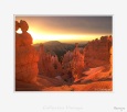
Bryce Canyon was not formed from erosion initiated from a central stream, meaning it technically is not a canyon. Instead headward erosion has excavated large amphitheater-shaped features in the Cenozoic-aged rocks of the Paunsagunt Plateau. This erosion exposed delicate and colorful pinnacles called hoodoos that are up to 200 feet (60 m) high. A series of amphitheaters extend more than 20 miles (30 km) within the park. The largest is Bryce Amphitheater, which is 12 miles long (19 km), 3 miles wide (5 km) and 800 feet deep (240 m).
The highest part of the park at 9,105 feet (2,775 m), Rainbow Point, is at the end of this scenic drive. From there Aquarius Plateau, Bryce Amphitheater, Henry Mountains, the Vermilion Cliffs, and the White Cliffs can be seen. Cope Canyon, where it exits the park in the north-east section is the lowest part of the park at 6,600 feet (2,011 m). (Source Wikipedia)
![]()
© 1998-2026 - C. Cassegrain Photograph - All rights reserved v.01 - Mobile : +33 6 71 26 04 76 |