
![]()
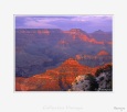
The Grand Canyon is a massive - in places over a mile (1,609 m) deep - 277 miles (446 km) long rift in the Colorado Plateau that exposes uplifted Proterozoic and Paleozoic strata. The Grand Canyon is unmatched throughout the world for the vistas it offers to visitors on the rim. It is not the deepest canyon in the world - both the Barranca del Cobre in Northern Mexico and Hell's Canyon in Idaho are deeper - but Grand Canyon is known for its overwhelming size and its intricate and colorful landscape. Geologically it is significant because of the thick sequence of ancient rocks that are beautifully preserved and exposed in the walls of the canyon. These rock layers record much of the early geologic history of the North American continent. Grand Canyon is also one of the most spectacular examples of natural erosion in the world.
 Uplift
associated with mountain building events later moved these sediments
thousands of feet upward and created the Colorado Plateau. The higher
elevation has also resulted in greater precipitation in the Colorado
River drainage area, but not enough to change the Grand Canyon area
from being semi-arid. The uplift of the Colorado Plateau is uneven,
and the north-south trending Kaibab Plateau that Grand Canyon bisects
is over a thousand feet higher at the North Rim (about 1,000 ft/300
m) than at the South Rim. The fact that the Colorado River flows in
a curve around the higher North Rim part of the Kaibab Plateau and closer
to the South Rim part of the plateau is also explained by this asymmetry.
Ivo Lucchitta of the U.S. Geological Survey first suggested that, as
the Colorado River developed before significant erosion of the region,
it naturally found its way across or around the Kaibab Uplift by following
a "racetrack" path to the south of the highest part of the
plateau. Almost all runoff from the North Rim (which also gets more
rain and snow) flows toward the Grand Canyon, while much of the runoff
on the plateau behind the South Rim flows away from the canyon (following
the general tilt). The result is deeper and longer tributary washes
and canyons on the north side and shorter and steeper side canyons on
the south side.
Uplift
associated with mountain building events later moved these sediments
thousands of feet upward and created the Colorado Plateau. The higher
elevation has also resulted in greater precipitation in the Colorado
River drainage area, but not enough to change the Grand Canyon area
from being semi-arid. The uplift of the Colorado Plateau is uneven,
and the north-south trending Kaibab Plateau that Grand Canyon bisects
is over a thousand feet higher at the North Rim (about 1,000 ft/300
m) than at the South Rim. The fact that the Colorado River flows in
a curve around the higher North Rim part of the Kaibab Plateau and closer
to the South Rim part of the plateau is also explained by this asymmetry.
Ivo Lucchitta of the U.S. Geological Survey first suggested that, as
the Colorado River developed before significant erosion of the region,
it naturally found its way across or around the Kaibab Uplift by following
a "racetrack" path to the south of the highest part of the
plateau. Almost all runoff from the North Rim (which also gets more
rain and snow) flows toward the Grand Canyon, while much of the runoff
on the plateau behind the South Rim flows away from the canyon (following
the general tilt). The result is deeper and longer tributary washes
and canyons on the north side and shorter and steeper side canyons on
the south side.
Temperatures on the North Rim are generally lower than the South Rim because of the greater elevation (averaging 8,000 ft/2,438 m above sea level). Heavy rains are common on both rims during the summer months. Access to the North Rim via the primary route leading to the canyon (Arizona State Route 67) is limited during the winter season due to road closures. Views from the North Rim tend to give a better impression of the expanse of the canyon than those from the South Rim. (Source Wikipedia)
![]()
© 1998-2026 - C. Cassegrain Photograph - All rights reserved v.03 - Mobile : +33 6 71 26 04 76 |